Environment -
Public Rights of Way
Public Rights of Way
Watstone Farm to Dovesdale
Farm (S/1)
Watstone Farm to Grossyett Knowe (S/2)
Bogside Farm to Dykehead Farm
(S/3 via Brankston House)
High Lanrigg to Bogside Farm (S/4)
High Lanrigg to Low Lanrigg (S/5)
Couplaw Farm to Bogside Farm (S/6)
Couplaw Farm to Tanhill Farm
(S/7)
Chapel Farm to Crumhaugh Farm (S/8)
East Hazeldean to Lonsdale (S/9)
Tweedieside to Hazeldean (S/10)
Spectacle E’e Falls (S/11)
Overhall and Tweedie Mill (S/12)
Bridgeholm Farm to Knowetop Farm
(S/13)
Old Stonehouse Road to Glassford
Bridge (S/14)
West Mains Farm to Horsepool
(S/15)
Holm Farm to Glassford Road (S/16)
CLICK
HERE
FOR
A GOOGLE MAP OF STONEHOUSE RIGHTS OF WAY
Public Rights of Way
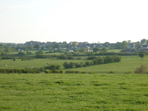
The most publicised and successful of all
the Heritage Group projects has been the restoration, maintenance and
monitoring of our seventeen public rights of way in our surrounding
countryside.
In consultation with the Local Authority and the Scottish Right of Way
Society, the Heritage Group have undertaken to periodically survey all
of the rights of way to identify hazards and obstructions to walkers.
In general most landowners have been supportive of the Heritage Group,
assisting through consultation on the erection of sign posting and
allowing unrestricted access to foot paths. However, there has
occasionally been conflict, in particular with the destruction of the
right of way at Dovesdale.
Since I produced a right of way booklet in 1993, the Heritage Group
have organised regular guided walks throughout the parish and beyond,
providing welcome recreational access to enjoy and explore our
magnificent environment.
Whatever the future holds for our historic sites, it is equally
important that we endeavour, as a community to record the relevant
information for future research and learning. By investigating and
writing of our past, it has often been frustrating in accessing
subjects, or sites known locally which have long since disappeared. I
hope that in compiling my research others will take enough interest to
further my work and provide residents and their descendants with a
greater understanding and knowledge of our cultural heritage.
Watstone Farm to Dovesdale Farm (S/1)
On the left just past Watstone farm buildings is the entrance to this
580 yard right of way. It consists of a farm track, 16ft wide,
narrowing to 4ft towards the end, where it becomes a grassy path
leading to a ford over the Cander Water. Care must be taken crossing
the ford if the river is in spate. The path ends alongside Dovesdale
farm. Points of interest on this right of way include Watstone farm,
Dovesdale farm, the banks of the Cander Water and excellent views over
the surrounding countryside.
This right of way dates to around 1864; part of a Road connecting
Stonehouse to the Glasgow/Carlisle Road crossing the Cander Water by
the ford.
Watstone Farm to Grossyett Knowe (S/2)
As with S/1 this 1200 yards right of way begins at Watstone farm
buildings and carries straight on but instead of turning to the left
(for S/1) turn towards the disused railway line and over a bridge. This
stretch has hedge rows with open pasture beyond. At this point the
right of way swings sharp right along a grassy mound exiting on Spittal
Road. There are excellent views across the open countryside, over
Cander Water and Overwood quarry. Rabbits, hares and weasels are among
the wildlife to be seen in this area.
This right of way appears on the 1864 Ordnance Survey map as a road
linking West and East Watstone with the Spittal Road. Right of the
disused railway, there was a road to the left which went to Overwood
farm crossing the Cander Water, by a ford alongside the quarry, to the
farm and on to Carlisle Road just beyond the exit from S/1. This was
before the railway was built.
Overwood Quarry worked from 1870 to around 1910 supplying stone in
quantity for tenement buildings in Glasgow, intermediate towns and
districts. A wooden footbridge crossed the burn, the workers way lay
either by Union Street or Boghall Street. A light railway, built to
connect the workings with Candermill Road, contained a spidery iron
viaduct when crossing the Overwood/ Candermains gully, which appears to
have been badly engineered. The light engine made one crossing only
carrying a terror striken driver, the viaduct remained mobile, as
improvisation of hand-trolley or ‘boggy’ served for transportation
across the gap. Towards the end of the first world war the
structure was dismantled and the metal sent to Fullwood Mossend for
scrap conversion.
Overwood unfortunately produced a serviceable but not high quality
sandstone, which the hewer found extremely difficult to work. It is
described as having no ‘reed’ and many a builder was said to by-pass
jobs on which it had scheduled. It did not weather and wear evenly, the
face tending to scale and rot set in. This ultimately led to the
quarry’s closure, and while accessible from the Mill Road for many
years afterwards, became a forgotten area, more so when the adjacent
farmer barred approach by grazing a bull in the field.
Bogside Farm to Dykehead Farm (S/3 via
Brankston House)
This right of way begins at Bogside Road 280 yards from Bogside farm.
The path starts as a farm track 8ft wide narrowing at Brankston cottage
to a 3ft grassy track. Watstone burn is then crossed by a footbridge
where a grass path leads up to lower Dykehead farm. Continue through
the courtyard down to Dykehead Road, a distance of approximately half a
mile. There are good views of the surrounding countryside, and a very
pleasant wooded area around Brankston House.
There has been some name changes between 1864 and 1898 when Brankston
House and Brankston Cottage were known as Dykehead and Dykehead
cottage. The Right of Way was a Farm track and road combination with
links through to Townhill farm (see S/7) and Couplaw farm (see S/6)
crossing the Roman Road in two places.
High Lanrigg to Bogside Farm (S/4)
This right of way is a farm track throughout its half a mile length,
going between High Lanrigg and Bogside farms. It is bordered by grass
verges and hedges with open pasture land beyond. There are some
interesting views of surrounding farms and to the South-West Brankston
House is in a nice woodland setting close to Dykehead farm.
This farm road, linking High Lanrigg and Bogside, goes back beyond
1964. The latter part of this right of way incorporates part of S/3 and
could make an alternative finishing point - Dykehead Road.
High Lanrigg to Low Lanrigg (S/5)
This footpath, l mile long, begins like S/4 on the Bogside Road close
to High Lanrigg farm; being a grassy track linking the two farms. It
crosses open pasture land and a gully with Watstone burn at the bottom
of the field. A farm road passing Low Lanrigg leads to Burncrooks and
Spittal Road for Stonehouse.
Near Burncrooks entrance, where the road crosses Watstone Burn, the old
bridge which carried the road over the burn can be seen in the field
with no road near it. The road from Low Lanrigg to Burncrooks went to
the left then crossed the burn at right angles to its flow to avoid an
awkward approach across the burn. Later bridge builders took a bridge
across the burn at this awkward spot and straightened the road out to
Spittal Road.
The farm names on this right of way give a clue to the shape and size
of their fields. Lanrigg is a corruption of Long Ridge indicating that
the old ridge and furrow system of farming being used when the farms
first came into use. The fields were of a size that when using a horse
and plough a good long ridge could be formed thence the names.
Along this right of way the farmer has utilised a dry-stone dyke for
bottoming to enable the track to carry the heavier modern farm
implements. This right of way also predates 1864.
Couplaw Farm to Bogside Farm (S/6)
This half mile long right of way starts at Bogside farm; the first
hundred yards of which can be excessively muddy in wet weather. The
path then changes to a grass track, about 15ft wide. Throughout its
entire length it is bounded by trees and shrubs, barbed fencing and
except for exceptionally dry periods of weather tends to be marshy
under foot. This is probably due to the fact that in the middle of the
last century this was a road linking Bogside, Couplaw and Tanhill
Farms. Over the years it has become overgrown and the old road below
the present vegetation does not drain sufficiently to provide good
walking conditions.
About a half mile from the start, the road turns left through heath and
marshland to cross the Roman road and onto Bogside farm. The last 80
yards before Bogside farm is completely blocked with saplings and
shrubs.
There are excellent views to be had at various points along this right
of way, most notably the section overlooking Loch wood to the East.
There is also a great variety of wild life - fox, badger, deer, a good
variety of butterflies and moths and numerous species of fungi. People
using this right of way would have to be properly equipped,
particularly footwear and reasonably fit.
Couplaw Farm to Tanhill Farm (S/7)
As with S/6 this right of way starts at Couplaw farm where the first
100 yards can be extremely muddy during inclement weather. Gradually
the pathway changes to grass, bounded by trees, hedges, some sections
of stone wall and barbed fencing. Where S/6 turns off to the left, this
right of way carries straight on and crosses the Roman road and out of
old Hamilton District into old Clydesdale District and thence on to
Tanhill Farm.
As with S/6 this right of way can be particularly wet, even in the best
of weather. This is due to the fact that this right of way was once a
road between Couplaw farm and Tanhill,. The route has become overgrown
and what drainage there was on the old road has become ineffective. The
Roman road in evidence today is in most parts through woodland and open
heath near Chapel farm.
Interesting features include the Roman road, views across Loch wood and
the ruined farm house at Castlehill. Wildlife includes fox, deer,
badger, a good variety of moths and butterflies and numerous species of
fungi.
Chapel Farm to Crumhaugh Farm (S/8)
Starting at Udston Road opposite the entrance to Chapel farm, this
right of way is approximately 1 mile in length. To begin the route is
heavily tree-lined and remains so for most of it’s length. The track,
being mainly earth covered stones, can be muddy during inclement
weather. The track varies from 10 to 15ft wide. It passes the rear
entrances to Greenburn and East Hazeldean farms onto open pasture land
past a small wood. Here the path crosses an open field towards a stile
ending in a farm track.
Over a century ago this is shown on maps as a road starting at end of
track at Chapel farm with plantations alongside the road, either side
of the entrance to Greenburn farm. There are some excellent views
across the surrounding countryside particularly to the North- East and
to Stonehouse.
East Hazeldean to Lonsdale (S/9)
This right of way starts just off S/9 at the Hazeldean entrance. The
path is tarmac at the start but changes to hard packed earth bounded by
fencing, hedges and some trees. 1100 yards long, the path varies
between 8 and 12ft wide and affords good views over the surrounding
countryside. It ends at a bend on Udston Mill Road near Lonsdale. This
right of way can be linked with S/9 (Chapel to Crumhaugh) and S/11
(Hazeldean to Tweedieside).
This right of way was at one time used as a drove road to market.
Tweedieside to Hazeldean (S/10)
Opposite the entrance to Tweedieside farm, off the Sandford Road, is
the start of this right of way. It is an old overgrown road
incorporated into fields near Hosenette farm. Along this section are
the remains of an old stone wall with Beech and Hawthorn growing out of
it. At Hosenette farm the path changes to tarmac, at High House to red
ash and at Hazeldean to a farm track. The right of way varies in width
from 3ft grass track to a 20ft road surface.
Points of interest along the 11/3 miles of this right of way include
dry-stone dyking, several farms, a ruined house with enclosed wall to
the left between Hosenette and High House. Many clear uninterrupted
views across the surrounding countryside.
The right of way ends on the road between Crumhaugh and St. Lawrence’s
Chapel (Chapel farm).
There is a good variety of birds to be seen along this Right of Way
including, Grouse, Wagtails and Sparrow Hawks. Deer have also been
reported in the area.
The 1864 Ordnance Survey map shows this right of way with a slight
change going past Hazeldean which is named as ‘Burn’ on this map and a
later map of 1898.
Spectacle E’e Falls (S/11)
The start of this right of way is reached through Sandford village,
down Waterside Street, alongside the Kype Water. Just past Tweediemill
there is a notice at the start of the right of way, near a small gate
on the wall. This gate leads to a grass track alongside a garden,
across the corner of a field, to a small footbridge over a gully. From
here a fenced path leads past a bench with an excellent viewing point
over the Kype Water. Steps are then taken down to the ruins of a mill
house and a viewing platform is found below Spectacle E’e falls.
The path continues to follow the course of the Kype Water to it’s
junction with the river Avon and ends at a single beam footbridge
across the Avon.
Points of interest along the 1015 yards of this right of way include,
Sandford village, Smithy Cottage Tweediemill House, Spectacle E’e
falls, Netherside farm and views up and down the river Avon at the
junction with Kype Water.
The name Spectacle E’e may have been derived from the Latin word
“Spectacali” meaning “a Spectacle’. However there is a strong local
tradition that the name is associated with a thatch fire at the Mill
said to have been caused by the lenses of a pair of spectacles. Placed
in the thatch and the glass caught the suns rays, setting the thatch on
fire. Apparently the Miller had forbidden his daughter to meet a local
youth who in revenge set fire to the Mill.
Overhall and Tweedie Mill (S/12)
A half mile from Sandford Primary School on the Sandford Road, a gate
leading to a track is the start of this right of way. The first half of
this half mile right of way is an overgrown grass track with a small
mixed wood on the right and a dry-stone dyke to the left. At the end of
this wooded section, the path takes a sharp left onto red ash, past a
stone dyke to the entrance of Wallkmill farm on the right and thence
over a small stream past Overhall and Tweediemill to Sandford village.
It passes the start of S/12 Spectacle E’e falls.
The right of way at various points has interesting views across the
surrounding country and Strathaven.
The ordnance survey map of 1911 County of Lanark, shows this as a road
from the Mill to Overhall, round to Sandford and Stonehouse Road.
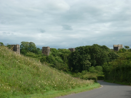
Bridgeholm Farm to Knowetop Farm (S/13)
On Strathaven Road near Glassford bridge this right of way begins
alongside the Avon river past Bridgeholm farm. The track is tarmac
surfaced from Strathaven Road to the farm but changes to grass past the
farm up an incline to the disused railway line. The track has to
deviate to the left at the base of the embankment to pass under the
railway and regains it’s original line along the other side of the
embankment. From here it follows the line of the fencing across fields
to exit on the Sandford Road below Knowetop farm. The track varies
along it’s 1150 yards length between 3 and 9ft.
There are good views of the surrounding countryside and the many farms
in the area.
The track as a farm road goes back beyond the middle of the last
century, before the railway was built, linking Bridgeholm and Knowetop.
The 1898 0rdnance Survey map shows it without the deviation to get
under the railway. The Stonehouse branch of the railway finished at Cot
castle.
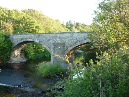
Old Stonehouse Road to Glassford Bridge
(S/14)
This right of way starts on Sandford Road at Crumhaugh bungalow. The
farm track with a slightly rocky surface has a small stream along the
left hand side with hedges on the right. The track is 626 yards long
and 12ft wide, passing under a disused railway track before carrying on
down to Strathaven Road near Glassford bridge. The exit occurs at a
bend on the road and caution is necessary here as there is no pavement
for pedestrians. Glassford bridge spans a fast section of the river
Avon where fishing is available with a permit, obtained locally. The
track gives excellent views over the surrounding farmland and the banks
of the Avon. Among the wildlife to be seen are Fox, Kestrel, Heron, and
Kingfishers. The right of way dates before 1864 and the railway.
West Mains Farm to Horsepool (S/15)
Beyond West Mains farm on the Udstonmill Road, this right of way lies
on a farm track winding it’s way past a wooded gully and stream, to a
grass track at the river Avon. Three quarters of a mile long, the path
varies in width from 15ft at the top, past hedgerows, to 3ft on the
grassy stretch. Good views of Stonehouse viaduct and the Avon river are
the main attractions of this right of way.
The 1864 ordnance survey map shows the start of the right of way as
part of Manse Road with a path forking left down the burnside to Mill
Holm field ending at Horsepool.
Mr. George F. Wilson in his privately published memories “Hame” writes
of this area:
“A full half mile further
down in the valley opposite West Mains we accepted the river as our
own, this, our boundary bathing
spot at Keirs, with the horse-pool deepest and only for the seasoned
swimmer next in sequence, and a few hundred yards nearer home. The ‘pool’ road descended
valley wards from the intersection below ‘Glen Mark as it still does,
but then was in constant use
by young and old, it’s Sunday Walk following Allan’s cart track along
the edge of the extensive cultivated Milnholm Field to the HorsePool, then a narrow
field track round the short bend, continuing a service purpose along
the almost parallel return
course of the river until the narrowing end allowed cross access to the
drinking-trough and return road ascent. The reverse direction up-river at the
horsepool gave entrance to Allan’s braes and our boundary pool. From
the high vantage point of old
St.Ninian’s, further down Avons coursing, the expansive cultivated
river enclosed field, enveloped by low encasing braes in upward unfoldings from the river
banks, presents a picturesque view of encircled river and field”
Holm Farm to Glassford Road (S/16)
This right of way starts past the entrance to Holm farm. The track is
composed of hard packed earth which changes into open pasture land. It
is in a reasonable condition. The track starts at a width of 15ft but
once into the field it narrows to a few feet. It is hedged and fenced,
also a small electric fence, although through the field there is open
pasture to the left.
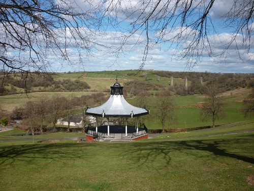
From the top of the track excellent views of the Alexander Hamilton
Memorial Park, railway viaduct and surrounding countryside
can be seen.
This right of way ends at a field gate leading onto Glassford Road.
On the 1864 and 1898 ordnance survey maps this 905 metres right of way
follows exactly it’s present day course and is, as it always has been,
an access route onto the Glassford Road.
|
|