General
History
-
Lost
History
Lost History
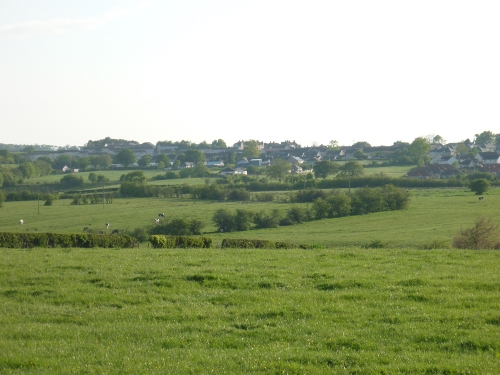
Law Mound
Cander Fortification
Lost History
Since the Heritage Group was established in 1991 a wealth of
documentation has been compiled relating to the history of Stonehouse,
both from local residents and around the world. I have continued my
research since leaving the Heritage Group in 1996, and strive to record
the historical past and investigate unchartered knowledge of the
development of the people and environment of Stonehouse.
In collating such material I have often found the occasional error, or
contradictory statements relating to dates, origins, or locations of
subject matter. Identifying the correct source of information is quite
often a matter of weighing up the case for and against recognition,
such as the location of Kemps castle.
However, there are two sites in
particular which, to this day I cannot confirm their existence, or
location, which appear to pre-date any recorded history of the parish.
Law Mound
In the Spring of 1998 I met a resident in the village who recalled a
newspaper article of around 20 years previous, which gave an account of
an unrecorded prehistoric burial site, off the Fairy Burn, near
Sandford. The gentleman informed me that the two local men who found
the site, did not want to reveal the precise location of the site
because it lay on private land.
With very little information to go on, and no time to sift through
possibly 30 years of newspapers, I resolved to find the location of the
alleged burial site. There is a recorded burial mound near Tweediehall,
which I initially thought the two men may have mistaken for a new
undiscovered site, but the gentleman who informed me of the newspaper
article was adamant it was off the Fairy Burn and not previously
recorded.
First confirming this information with the Royal and Ancient Monuments
of Scotland (RAMS) in Edinburgh that no such site existed, I set forth
with my walking partner for the day, Steven Bunch. The only other piece
of information I was provided with was that the burial site had been
exposed to the elements, which initially seemed strange, as no one had
thought to recognise the significance of the site before.
On reaching the Avon we came to the mouth of the Fairy Burn, whereby we
followed its course past the Whyte monument, over Stonehouse Road, past
the lime works and the wind pump to Law farm. Veering right, we
initially thought we may have come too far, after seeing no evidence of
a burial site. We marched on following the burn until we reached the
right of way which runs from the Sandford Road past Law farm, where we
found what may be a prehistoric burial mound.
I had passed this site before, thinking it was an unnatural feature in
the middle of what is farm land, but the thought that this was a burial
mound never crossed my mind until I was given information of a possible
new site of historical importance. On closer inspection the mound was
spherical in shape, some 30-40 metres in circumference and 3.5 metres
high. Similar to other sites locally, the mound appeared to have been
ransacked in the past, such as the case with Mount Pisgah near West
Mains estate around 1834. Resting prominently, only 200 metres north of
the right of way, the mound is also adjacent to the Roman Road, which
crosses from the direction of Chapel Farm towards Loudonhill. A
recorded burial mound lies not a half mile south of this site, directly
on the line of the Roman Road towards Chapel Farm, though there are no
details recorded of its origins or contents.
From all the information available to me, the appearance and the
location in relation to other recorded sites, I was convinced we had
found a new unrecorded prehistoric site.
I was advised by the RAMS to contact the West of Scotland
Archaeological Service who undertook a site inspection in the Summer of
1998. However, without a proper excavation of the site, they could not
confirm if the mound was natural or artificial, as the mound may be a
natural glacial mound that had been quarried.
It was clear more information would be needed, either from the two men
who first located the mound, or by an organised, detailed
investigation, before determining its classification. With neither the
finances, resources or knowledge of the original sources, further
information is required to confirm the origins of the site.
Despite the lack of information two further interesting points of note
support the possibility that the mound is a prehistoric burial site.
Firstly, a food vessel and a type of bronze age pot are held in a
collection at the Hunterian Museum in Glasgow, which are recorded as
coming from Law farm, Stonehouse. However there are no details
registered regarding the circumstances of the finds, apart from a
reference in a publication in 1946. These items may have been submitted
to the museum as far back as the last century. In 1836 Rev. Dewar
recorded in reference to the burial site at West Mains, - “There have
been other Tumuli in the parish, particularly one at the upper end of
it, which, some years ago, was ransacked to the centre, and a number of
urns found therein”.
A second point of interest is that ‘Law’ is an old Scots word meaning;
1. a rounded, conical hill, isolated and conspicuous 2. an artificial
mound or burial mound. Whether this is a reference to this site or mere
coincidence we can only guess.
Cander Fortification
Another site of intrigue and mystery is the possibility of an
unregistered ‘Keep’ (castle) or fortalice, as Robert Naismith describes
in 1885. He indicates, “The
fortalice of Cander commanded an excellent
position on the banks of the Cander
Water, and seems to have been in
decay in 1700”, yet on consulting all maps from the period, as
far back
as 1596, there appears no record of a castle on the Cander Water.
Robert Naismith again mentions the stronghold in relation to the
Hamilton family of Cander, stating, “the fortalice of Cander stood so
near to the town”. This would suggest that a family keep was present in
close proximity to the North-Eastern end of the village.
As I have found no records other than Naismith’s quotes, my personal
theory would be that the ‘fortalice’ was sited on the elevated ground
where Candermains farm is now situated. This would support the
information provided and make practical sense. If sited here, the keep
would have commanded an excellent view of the surrounding landscape as
described, as well as being protected by the high banking down to the
Cander Water.
There is also a mention of a dwelling on Ponts map of 1596, indicated
as ‘Kand’ at this location, and Charles Ross’s map of 1773 as Kander,
to which I believe refers to the Hamilton family home. Unfortunately,
further documentation is needed to determine the location of the
structure in question. The nearest fortifications are Cot castle, Double Dykes and Ringsdale
castle. Interestingly, Ringsdale castle,
although
being
identified
quite
clearly on a number of local reference
maps, appears where Candermains rests on an ancient parochial map of
Scotland. Why this is so, I do not understand, as the map appears quite
accurate in relation to other local landmarks of the period.
On William Forrest’s map of 1816, Candermains Farm is situated south of
‘Ryehill’, on the Cander Water. Could it possibly be that an earlier,
or later Ringsdale Castle was present near this location than the
commonly acknowledged site, as identified on the ancient parochial map
of Scotland?
Robert Naismith suggested that Ringsdale Castle originated from ‘Rhyn’,
the ancient Briton word for promotory or hill, but an account of
Stonehouse in 1937 states ‘Rings’ is a corruption of Ninian, as in
Ringwell Gardens, which is said to derive from Ringan Well. Yet another
theory comes from Cosmos Nelson Innes around 1850, who suggests that
Ringsdale is a corruption of Rydenhill. If correct, could this not in
fact be a corruption of ‘Ryehill’.
A less unlikely corruption, but interesting all the same, is the
possibility that Ryehill or Rydenhill is a corruption of ‘Rydderch
Hael’, the Prince of Lanark and first sovereign of the district in
573AD, who
later became the ruler of the Kingdom of Cumbria later known as
Strathclyde. Converted to Christianity by disciples of Columba, he died
in 603AD. The Cumbrian kingdom ruled by Rydderch was steeped in
romanticism and tales of the mysterious King Arthur, who was said to
have existed during this period in history. Coincidentally, and most
curiously, a prominent bard by the name of ‘Merlin’ resided in this
district during the same period (6th century) and in 1981 the actor
Nicol Williamson, who resided in the parish for sometime, played
‘Merlin’ in the film Excalibur. Some may recall him playing Little John
opposite Sean Connery and Catherine Hepburn in ‘Robin and Marion’ in
1976.
It seems unlikely the location of Naismith’s ‘Cander Fortification’
will ever be uncovered, leaving us to speculate on the origins of this
site.
|
|