| Name of Place |
Date |
Origins / Description |
| Angle Street |
pre 1841 |
Probably named with reference to the ‘angle’ of the street. |
| Alexandra Terrace |
|
Street said to have been located at the end of Green Street to the right of the former railway embankment. Only reference to this street comes from George Wilsons ‘Hame’. |
| Argyle Street |
pre 1841 |
Probably named after Argyll Street in Glasgow. It was common place to use street names trading cities. |
| Avonview |
c1940 |
avon; Indo-European origin meaning a river or water. abhainn (Gaelic) |
| Beamers Walk |
pre 1975 |
A ‘beamer’ is a weaver who winds the warp onto a beam, and thereon to the loom. Wee Tam Sorbie was a local beamer at the turn of the century. |
| Beechwood Drive |
c1978 |
Presumably named after the common beech wood tree which is plentiful in the surrounding area. |
| Birksburn Avenue |
pre 1975 |
Originates from the burn and former farm near the Horsepool. The farm was present pre1816 but was recorded to be in ruin in 1858. birk; (Scots) small wood mainly consisting of birch trees. |
| Blackwood Loch |
pre 1596 |
Recorded as Sinkwell in 1816 (William Forrest). (Blakwood 1596 Pont) |
| Blinkbonny |
c1972 |
There are 29 settlements in Scotland called Blinkbonny or Blinkbonnie. They are found in non-gaelic areas, down from the eastern lowlands from Caithness to the Borders. The name indicates a patch of ground favourable for farming because it has a southern or protected aspect; Sunnyside and Morningside are place names of the same meaning. |
| Boghall Street |
pre 1841 |
bog; (Scots) 1. mire 2. work in wet dirty surroundings |
| Brankston Avenue |
c1940 |
Named after Brankston House, built between 1858 and 1898.
branks; (Scots) 1. a kind of bridle or halter 2. an instrument of public punishment, an iron bridle and gag used to punish breaches of the peace or abusive language. In 1560 Edinburgh Town Council passed a law that stated women who nagged their husbands would be punished by the ‘branks’. This was an iron frame, fastened onto the head, with a metal spike forced into the mouth.
The woman was then led through the streets on the end of a chain. |
| Bridgeholm |
pre1662 |
A John Hamilton (covenanter) of Brigholm is present in 1683. (Brigholme 1662) |
| Brodie Place |
c1988 |
Named after Labour County Councillor Robert L. Brodie who served Stonehouse between 1946 and 1958. |
| Cairnsmore Drive |
1970 |
Named after hill in Dumfries and Galloway along with several other streets deriving from hills across the Southern Uplands and South Lanarkshire. Named by Councillor Moyra Burns. |
| Caledonian Avenue |
c1930 |
Probably named after the railway which passes by the back of the street. |
| Cam’nethan Street |
c1830 |
Named after ‘Cambusnethan House’ the proprietors of which owned much of the land in Stonehouse Parish. Camnethan dates back to at least 1596. Construction of Camnethan Street took place between 1830-1840. Cam; 1. limestone, pipeclay 2. the tilt or angle given to a furrow as it falls over from the ploughshare. Cambus; (Gaelic) a bend or crook in a river. neth; beneath
nethan; may derive from the saint, Nethan |
| Candermains Farm |
pre 1596 |
From the map of Charles Ross 1773, this farm appears to have been formerly named Kander. |
| Ca’fauld |
|
Cow fold (1816 William Forrest) Calfauld was a place between Wellbrae and Sauchrie Cottage.
fauld; (Scots) cattle or sheep pen |
| Cander Avenue |
pre 1975 |
Named after the Cander Water. In 1750 a second Kander is located approximately where Canderside Farm is sited today. (Kand 1596 Pont) |
| Cander |
pre 1455 |
kand (kaner); a person appointed to oversee fishing (Kand 1596 Pont; castle on river not recorded after this date) May derive from ‘candie’ - a drain. |
| Castlehill |
pre 1596 |
Formerly the family residence of the Lockharts, this castle was said to be in ruins in a survey of Stonehouse in 1710. No remains in 1885. Also known as Kemps Castle. Adders were to be found in this area during the 1950’s. |
| Cot Castle (Coat, Kat) |
pre 1494 |
Naismith suggests that ‘Cat’ in the English and Gaelic language was the scene of a battle, but I can find no evidence of any battle. (Kat Castel 1596 Pont) The Hamilton Family resided here in 1500. Naismith stated a fortification of significant strength was present here, evidenced by the remains of the walls, which were in ruin. (Kat 1680, Catt 1750, Coat 1816, Cout 1821) cat; (Gaelic) a potato or corn heap cat; (Scots) ‘cat and clay’-a handful of straw mixed with soft clay used in the building or repairing of walls or buildings. cath; (Gaelic) a battle |
| Chalybeate Spring |
pre 1858 |
Situated near Nellies Burn at Castlehill. This spring can still be seen seeping through the grass, 10ft away from the burn at the foot of Castlehill. A Chalybeate spring contains water bearing iron salts, from the Greek khalups (steel). |
| Cloxymill |
pre 1725 |
The ruins of the mill are still evident on the Avon river near Ringsdale Castle. (‘Clocksy’ Mill in ruins 1859). A census in 1696 records a Raploch Mill in Stonehouse parish. Whether or not these are one and the same I am uncertain. |
| Cairncockle |
prehistoric |
This name derives from the prehistoric mound on the Carlisle Road. cairn; (Scots) a mound of stones erected as a memorial or marker. May derive from Gaelic carn chocuill (cairn of the gap).
The Munro ‘Beinn a’ Chocuill’ exists in Dalmally. (Garncochil, Pont 1596) |
| Collingair |
pre1600 |
Located near Dovesdale at the ford on the Cander with Watstoun. James Thomson’s (Covenanter) ancestors are said to have moved to Tanhill from Cunningair. |
| Corslet |
pre 1683 |
(Corslett 1773) cors; (Scots) to seek, search let; (Scots) a gate or hurdle used to stop up a gap in a hedge or a wall. Cors - in some Scots placenames is a metathesis of ‘Cross’. A Gavin Wood of Corslett (covenanter) is recorded in the year 1683. |
| Couplaw |
pre 1816 |
In 1816 there existed a house by the name of Cowplow which had a lime quarry near by. Coup; (Scots) 1. a rubbish tip, fall 2. buy or exchange 3. Plough up (the green strip between furrows)
law; conical hill, isolated, an artificial mound |
| The Cross |
|
Formerly known as Market Place (1868). |
| Crofthead |
pre 1618 |
Ancient settlement associated with Hamilton family. |
| Crookedstane |
pre 1618 |
(Cruckitstone 1618) Present farm located next to standing stone. |
| Crow Road |
c1980 |
Named after Rev. Crow of Paterson Church 1930-1952. |
| Crumhaugh |
pre 1596 |
(Krummock 1596, Krúnock 1654, Crumak 1773) crumak, crummock; (Scots) a shepherds crook cromag; (gaelic) - anything bent, a hook or a crook |
| Davidson Gardens |
c1980 |
Probably named after Dr. Davidson |
| Dick Court |
c1988 |
Named after Jean Dick |
| Dub (The) |
pre1900 |
Formerly the half acre open space off Angle Street, now called Leith Avenue. |
| Dunside Way |
1970 |
Derives from Dunside Burn, South of Sandford |
| Dykehead Farm |
pre 1696 |
Also formerly known as Headdykes Farm (near Roman Road) |
| Elrikhoom |
pre 1596 |
elrich; (Scots) resembling elves, weird, ghostly, strange, elrig: (Gaelic) a notch in hillside or a trap into which deer are driven by hunters. There are several places in Scotland by the name of Elrig or Elrich. |
| Flatterdub |
pre 1816 |
dub; (Scots) a pool, muddy or stagnant water |
| Foulmire |
pre 1816 |
(Foulmire, 1816 - Foulmyre 1858) mire; (Scots) a peat bog |
| Gallowhills |
Ancient |
There were formerly two Gallowhills, one near Watstoun Burn and a second at Kittymuir. There are, however, no records of any hangings taking place in the parish, to my knowledge. |
| Garibaldi Gates |
c1880 |
Gateway between Cander bridge and Canderside toll where a small gauge railway ran to the Spion Kop colliery. Garibaldi; Italian hero who fought to unite Italy in the mid 19th century. |
| Gemmell Way |
c1991 |
Presumably named after Dr. (Rev.) Gemmell, formerly of St.Ninian’s Church. |
| Gibb Court |
2001 |
Named after the late Councillor for Stonehouse. Named by myself. |
| Gill Cottage |
pre 1750 |
Gill; (Norse) ravine (Gill 1750 Charles Ross) |
| Goslington |
pre 1528 |
Location associated with Hamilton family. |
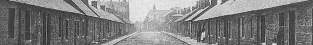
| Green Street |
pre 1841 |
Site where washing ‘green’was situated, evidenced on Ordnance Survey map of 1859. Feu title deeds state Green Street ‘stood on forty pence templar lands’ (G.F. Wilson). Greenside Place rested on the diagonal stretch of road between Miller Street and Green Street opposite the Masonic hall . |
| Graista hil |
pre 1596 |
grist; (Scots) bring-grist to the mill, corruption of Gristmill (Gráisthil 1654 Blaeu) |
| Hamilton Way |
c1991 |
Possibly named after Rev. W. K. Hamilton, the first minister of the former Hamilton Memorial Church in Green Street |
| Hawkwood Way |
1970 |
Originates from Hawkwood Hill South of Sandford in the Kype range. |
| Hareshaw Place |
1970 |
Hareshaw Hill lies to the west of Douglas. Hareshaw Burn is a tributary of the Kype. haire;
(Scots) 1. hare 2. the last sheaf or a handful of grain cut in the harvest field shaw; (Scots) a small natural wood |
| Hazeldean |
pre 1398 |
hasel, hasil, hazel; (Scots) an area covered in hazels dean, dene; (Scots) a local designation, possibly ministers residence (Hessildene 1398 - Hasildein 1596 Pont) |
| Hill Road |
pre 1841 |
Possibly named after Hill Cottage or U.P. Church Hill Manse which dates to at least 1815 |
| Holm |
pre 1596 |
holm; (Scots) a stretch of low lying land beside a river (Hoomhead 1596 Pont) |
| Hosenette Farm |
pre 1696 |
(Hosnet 1696 - Hosenette 1913) hosnet; a small stocking shaped net fixed to a pole, used for fishing, a trap |
| Inglis Court |
c1995 |
Named after Jimmy Inglis, who raised funds for charity with his group the Tartan Echoes |
| Keaphol |
pre 1596 |
keep; (Scots) fortified house hol; (Scots) shallow |
| King Street |
pre 1841 |
Probably named after King George IV or King William IV. The two storey building ajoining the Cross from King Street, now an Indian restaurant and Chip Shop (formerly belonging to Messers. Gray and Naismith) was known as Cut-Apple Terrace (G.F. Wilson). |
| Kirk Street |
pre 1820 |
Street that led to the old St. Ninian’s Church |
| Knoken |
pre 1596 |
cnoc: (Gaelic) a hillock - cnocan; a small hillock |
| Kobars |
pre 1800 |
High land at Holm Farm |
| Kittymuir |
pre 1362 |
Said to be derived from “kirk o’ the muir” (Kythumbre 1362, Kintumber 1390, Kittimur 1596, Kittimur 1689) muir; area of uncultivated land. kitty; (Scots) prostitute, bad girl, prison. Kitty fell;
(Scots) skin of sheep, slaughter, measurement of land (possibly a slaughter house?) |
| Knowetop Farm |
pre 1858 |
Formerly Side Farm. Knowe; (Scots) a hill e.g. ‘Ca the yowes tae the knowes’ (Robert Burns) |
| Langrigg View |
pre 1596 |
(Langrien 1596 - Longrig 1773) rigg; (Scots) a long narrow hill, ploughed strip of land (runrigs) |
| Langsyke Park |
pre 1800 |
Park opposite tilework park. syke; (Scots) a small stream or water course, boggy ground, a
marshy hollow |
| Law Farm |
pre 1696 |
law; (Scots) a rounded conical hill, isolated, a grave mound |
| Linthaugh |
pre 1596 |
lint; (Scots) a flax plant (Lintheach 1596 Pont) haugh; (Scots) a piece of level ground on the banks of a river |
| Lawrie Street |
pre 1841 |
Robert Naismith records the street as Laurie Street in 1884. Possibly named after a local worthy, a James Laurie was resident in the parish in 1696 (an elder of the established church). Formerly known as the ‘new toon’ to generations from 1780 onwards (G.F. Wilson). ‘Newtown’ (1851 census) |
| Leith Avenue |
2002 |
Derived from Plenderleith, local builder of distinction in Stonehouse. Named by Mrs Cranston. |
| Lockhart Street |
pre 1859 |
Named after the Lockhart Family who were past proprietors of land in the parish of Stonehouse.
Lockhart Place was formerly known as Cam’nethan Place. |
| Lonsdale Farm |
pre 1816 |
loune; (Scots) 1. a grassy track 2. a milking place 3. a street or roadway dale; (English) a piece of land 2. an ecclesiastical division of land |
| Lowther Crescent |
1970 |
Named after a hill near Wanlockhead. |
| Mainsacre Drive |
c1972 |
mains; (Scots) the home farm of an estate cultivated for or by the proprietor acre; measure of land |
| Manse Road |
pre l975 |
The road to the manse. This road is also referred to locally as ‘the Allan’s’ (farmers of Westmains) |
| Marlarge |
pre 1816 |
mar; obstruct, hinder, intercept, stop. This road was at one time a toll road out of Stonehouse to Overton. |
| Millburn Farm |
pre 1548 |
Although in the parish of Dalserf, Millburn has a close association with the past proprietors of Stonehouse. The Scottish ‘colourist’ painter Leslie Hunter (1879-1931) stayed here during the first world war with his uncle. While there he painted interiors of the farm and still lifes which have been exhibited world wide. (Milburn - 1596 Pont, Milburne - 1548) |
| Millheugh Road |
pre 1596 |
heuch; (Scots) a steep bank. The turn uphill from the river was known locally around the turn of the century as ‘Geordie Flit’. Other parts of the road down the brae were known as Girzel Knowe (Girzie; (Scots) maid servant) and Pennisten Knowe (pennystane; (Scots) a round flat stone used in quoits). At the same turn on the Millheugh Road, there was a road which continued on past the viaduct to an oil works. This road was known as the ‘Tinks’ road’. (Milheach 1596 Pont) |
| Millar Street |
c. 1750 |
Named after Thomas Millar who resided in this street. |
| McLean Gardens |
c1980 |
Probably named after Dr. Alex McLean (d1938 aged 80); physician for near 50 years. |
| McEwans Way |
c1988 |
Named after Labour County Councillor John McEwan who served Stonehouse from 1958-1967. |
| Merrick Drive |
1970 |
Named after a hill in Dumfries and Galloway. |
| Millholm Gardens |
pre 1683 |
(Milnholme - 1696) There formerly stood a mill near the Horsepool named Millholm in 1768. Traces of the mill can still be found on the Avon adjacent to Allan’s Haugh. A legal document dated 1797, granted a 999 year lease of ground in King Street, in which it stated - the “Perpetual Tack” of that year ... “all grindable corn ground on the siad piece of ground (Sweet-bryar park) to be taken to Millholm mill and the accustomed meal, bannocks and other duties paid”. Udston Mill Road was previously the main route to the mill. A John Hamilton of Milneholm is cited as a supporter of the Covenant in 1683. |
| Mount Pisgah |
prehistoric |
Probably named around the beginning of the 19th century. Name originates from the Holy Land in Jordan, north of the Dead Sea. Mount Pisgah is the highest point of the mountains of Abarim. The Israelites, led by Moses, reached “the valley lying in the region of Moab by the top of Pisgah which looks, down upon the desert” (Canaan) Nos. 21:20. Could it be that Ninian (like Moses), in coming from the west to our parish, looking down on ‘the promised’ land, had the idea of establishing a Christian community? A romantic theory perhaps, but doubtful. In Scotland there are three settlements by the name of Pisgah and three Pisgah hills including one near Greenock and another near Gatehouse-of-Fleet. |
| Munkstibbil |
pre 1596 |
munk; a noose, snare, religious preacher stibble; (Scots) a probationary minister in the presbyterian church |
| Muirhead Drive |
c1975 |
Either from the Rev. James Morehead, ordained in 1760 and probably the last minister to preach in the old kirk, or, Murhead in the parish of Dalserf dating back to 1596. |
| Murray Drive |
c1973 |
Probably named after Dr. Murray. |
| Murrayside |
c1972 |
Presumably named after Dr. Murray. |
| Naismith Court |
c1991 |
Named after Robert Naismith author of ‘A History of Stonehouse’ in 1885. |
| Neuk Farm |
pre 1696 |
neuk, nook; (Scots) a projecting point of land, an outlying or remote place (Nook 1696, Neuk 1773) |
| New Street |
pre 1841 |
Formerly known as the ‘Front Street’ George Wilson (Hame) suggests it was renamed c1850, though the street was identified as New Street in the 1841 census. |
| Puddock Lane |
pre 1850 |
puddock; (Scots) toad or frog. Where the Smithy was situated in Queen Street. This place originated when a barber returning from Strathaven fell into a pond full of frogs. |
| Overwood |
pre 1596 |
(Ouerwood 1596 Pont) Sandstone quarry sited here during latter half of the 19th century. |
| Parkhall |
pre 1756 |
Area between U.P. Manse and Queen Street. |
| Paterson Place |
pre 1975 |
Named after Rev. H.A. Paterson of the U.P. Church, who died in 1901.
|
| Patrickholm Avenue |
pre 1596 |
Probably named after either Partick Hamilton, the first preacher and martyr of the Scottish Reformation around 1503 or his father Sir Patrick Hamilton of Kinavel and Stonehouse. (Patrickhoom 1596 Pont) |
| Plotcock Castle |
ancient |
plotcock; (Scots) the devil (remains are still evident today) A rare ‘Adam and Eve’ stone sundial carving was found here, now situated at a farm in Ayrshire. The carving was probably incorporated into the ‘keep’ between the late 17th and late 18th century. Another theory is that the stone depicts Adam and Lillith’ (Adam’s first wife). Lillith was said to be a ‘she devil’ worshipped in witchcraft. |
| Quarry Road End |
|
Road leading to Ironstone mines near Double Dykes |
| Queen Street |
pre 1859 |
Named after Queen Victoria (reigned between 1837-1901), this street is often referred to locally as the ‘back road’. An old mile stone once stood here but disappeared in the mid 1970s |
| Reid Grove |
c1993 |
Possibly named after Wull Reid of Holm Farm |
| Ramscraig Gardens |
c1972 |
Pool on the river Avon |
| Ross Place |
pre 1881 |
Between Lawrie Street and Argyle Street, this street is named in the statistical account of 1881. |
| Ringsdale Castle |
ancient |
Naismith suggests Rings is derived from Rhyn; (Welsh) the language of the Ancient Britons,
signifying promontory or hill. The remains of what appears to be a ‘motte’ still here. |
| Ringwell Gardens |
c1972 |
Corruption of ‘St. Ninian’s Well’, sometimes known as Ringans Well |
| Ryehill |
pre 1816 |
Former farm opposite of the Cander from Woodlands Farm rye; a tall grasslike cereal grown for its light brown grain |
| Sandbed |
pre 1841 |
Area adjoining Parkhall and Queen Street. |
| Sandford |
pre 1596 |
ford; a shallow area in a river that can be crossed by foot or horseback (Sandfurd 1596 Pont, Sandyfourd 1750) |
| Secaurin Avenue |
c1968 |
1. ‘The house by the river’ (Latin?), 2. A Pool on the Avon bears this name; The most probable theory for the origins of this street name relate to a time when the Avon was in spate. A corner of the pasture land on Holm farm was in danger of being washed away and in an effort to ‘secure’ the dry stane dyke bounding the field, the laird and his servants would take steps to prevent further flooding; known in local dialect as “securing”; thus the corruption of the present name.
This Pool lies between Reid’s Haugh and Hazel Hole. |
| Shawhead Farm |
pre 1816 |
Near Crumhaugh Farm on road to Sandford. shaw; small woodland. There exist another nine
Shawhead’s in Scotland. |
| Sidehead Road |
pre 1859 |
Possibly derived from ‘Syde’ in the parish of Avondale in the ownership of Sir Robert Hamilton of Goslington in 1608. |
| St.Laurence Avenue |
pre 1581 |
(Chappole 1696) Named after St.Laurence’s Well at Chapel Farm. In 1820 a fair in Hamilton was named after St. Laurence. St. Laurence was a 3rd century Roman Christian who died in 258. He is celebrated on August 10th. Present Chapel farm was built in 1769. |
| Slaeholm |
|
So called on account of the braes here being covered with sloe bushes. |
| Sodom Hill |
|
Probably named in the late 17th century. From the Holy Land. Sodom was the chief city in the Plain, on which the Lord “rained brimstone and fire” (Gen. 19:24-5). Sodom is said to be on the southern border of the land of Canaan, but no evidence has been found of its existence. On the southern shore of the Dead Sea, a hill of salt is recorded as Mount Sodom. “Hear the word of the Lord, you rulers of Sodom! Give ear to the teaching of our God, you people of Gomorrah!” (Isaiah 1:10) A battle or skirmish is said to have been fought here, probably in relation to the Covenanters. |
| Spion Kop (Colliery) |
|
Boer War battle fought near hill of that name in 1900, resulting in heavy British losses. |
| Spittal |
pre 1596 |
spital; (Scots) a charity hospital, a hospice or shelter for travellers. The term is of Latin origin; hospitium - hence our hospital. Present Spital House built in 1723. (Spittel 1596 Pont) It is said, “All passers by were provided with food and a night’s quarters free of charge; even the rich were left to acknowledge their entertainment by making a voluntary offering to the coffers of the institution”. St. Anthony’s Holy Well is situated in the grounds of Spittal House. He was an Egyptian hermit (b. 251, d. 356) whose remains were lost for two centuries, before being rediscovered at La Motte, where the ‘Order of Hospitallers of St. Anthony’ was formed in 1100.
The saint is celebrated on January 17th. Nicknamed Snail Street (G.F. Wilson). |
| Spinningdale |
c1972 |
Named after the weaving industry in Stonehouse. A village named Spinningdale exists in Sutherland. |
| Sorbie Drive |
c1988 |
Unknown. An old Stonehouse surname mentioned in Black’s surnames of Scotland. |
| Stank |
pre 1756 |
Formerly situated at left side of Angle Street facing the Cross with a massive dung heap at the front of the dwelling. A Thomas Millar resided here in 1756. stank; a ditch or gutter |
| Sutherland Avenue |
c1950 |
Named after Superintendent Physician Dr.. Sutherland (d1929 aged 46) of Stonehouse County Orthopaedic Hospital. Came to Stonehouse from Helmsdale. Hon. Pres. of Stonehouse Violet FC. |
| Sweet-bryar Park |
pre1797 |
Ground on which Galloway & MacLeod Ltd utilise in King Street. |
| Thinacres Farm |
pre 1596 |
aker; (Scots) acre. Probably from the runrigs, still in evidence near Darngaber ‘motte’. (Thinaker 1596 Pont) |
| Todlaw Way |
c1971 |
Todlaw Hill lies South of Sandford in the Kype range. |
| Todstable |
c1968 |
Tod’s Table, where a tod, (Fox) is said to have hidden from a pack of pursuing hounds under a stone slab. Todstable and Secaurin Avenue were first streets to be built in Westmains estate. |
| Tofts |
pre 1674 |
tofts; (Scots) a homestead and its lands. Formerly Templar lands |
| Trongate |
pre 1841 |
Probably named after the Trongate in Glasgow |
| Thomson Court |
c1996 |
Probably named after the Covenanter James Thomson of Tanhill, killed at Drumclog in 1679, buried in old kirk yard. |
| Townhead Street |
pre 1841 |
(Tounhead 1596 Pont) Toun head is a very common Scots name for the ‘ferm toun’ at the head of the farm area (e.g. Tounhead in Glasgow and Coatbridge)- nothing to do with ‘town’ in the modern sense. |
| Tweediehall |
pre 1498 |
twee; (Scots) a call to calves at feeding time (Twedy and Tueedyhil, 1596 Pont) |
| Udston Avenue |
pre 1975 |
The farm of Uds-‘toun’ dates back to at least 1697. stoun, ston; (Scots) a tree stump or tree left after felling |
| Union Street |
pre 1841 |
Possibly named after Union Street in Glasgow where weavers traded with local merchants.Formerly known by locals as Snail Street, as it was said that snails abounded in the gutters and ditches. |
| Vicars Road |
pre 1667 |
The vicar’s lands lay between the village and the Avon. vicarage; (Scots) land before the
reformation allocated to vicar. |
| Wassocks |
pre 1800 |
Park where Meadowside Cottage is situated. wassock; (Scots) a bundle of straw used as a torch |
| Watson Avenue |
pre 1975 |
Unknown. May derive from Watstone Farm. |
| Watstone Farm |
pre 1498 |
toun; (Scots) an area of arable land occupied by a number of farmers or tenants, a farm with its buildings and surrounding area (Watstoun 1596) |
| Waukmill |
pre 1696 |
walk, wauk; (Scots) to shrink cloth after wetting. Common place-name in Scotland. |
| Weavers Way |
pre 1975 |
Named after the weavers who plied their trade in the village. |
| Wellbrae |
|
Formerly a bleaching green and source of water supply. |
| East/West Mains |
pre 1696 |
mains; (Scots) the home farm of an estate cultivated for or by the proprietor. |
| Whinriggs |
c1972 |
whin; 1. hard rock, 2. gorse rigg; a long narrow hill, ploughed strip of land |
| Wilson Place |
pre 1975 |
Named after Councillor Thomas Wilson (d1955 aged 82); founder of Wilson Builders Ltd. |
| Woodland Farm |
pre 1674 |
Self explanatory |
| Wullie Sma’s Road End |
|
Diagonal pathway between Canderside farm and the Toll. |
| Yards Farm |
pre 1696 |
yaird; 1. Yard (Scots measure), 2. a garden, 3. a church yard or playground |